Surveying the Permafrost With a Robot
03/18/2025Researchers from the University of Würzburg have used a new technology to measure a permafrost tunnel on the Zugspitze. The system enables high-precision 3D images to be taken even in environments that are difficult to access.
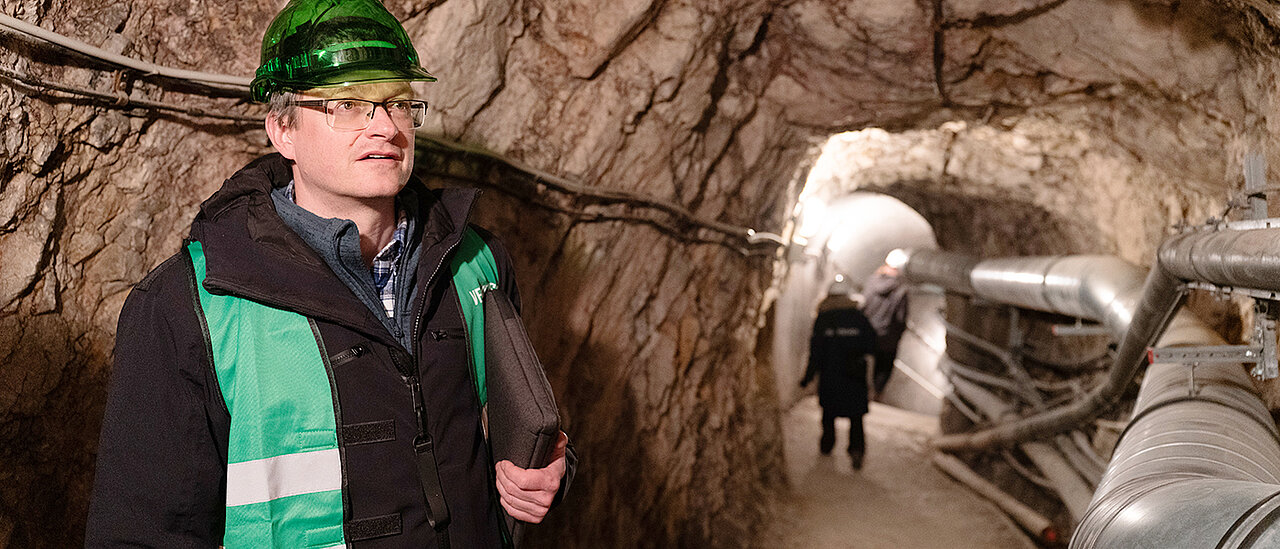
A tunnel has been running through the upper section of Germany's highest mountain, the Zugspitze, since 1926. Drilled so that skiers could walk from the Austrian cable car to the ski area on the German side of the summit, the tunnel now ends in the basement of the Schneefernerhaus. It used to house a hotel; the building is now a globally unique environmental research station. And since January 2024, Julius-Maximilians-Universität Würzburg (JMU) has been one of several institutions that use the Schneefernerhaus for their research.
The first research result achieved by a JMU team in this region is now available: the robotics working group led by Professor Andreas Nüchter has successfully tested a so-called "spherical mobile mapping system" for 3D mapping of the alpine permafrost tunnel on the Zugspitze. Nüchter heads the Chair of Computer Science XVII at the Institute of Computer Science, specialising in robotics.
A Technology With Many Areas of Application
"Modern 3D mapping is of central importance for numerous applications such as autonomous driving, building inspections, space travel and environmental mapping," says Andreas Nüchter, explaining the background to the project. Technologies such as backpack-mounted LiDAR scanners or drones are generally used for this. Researchers from the Chair of Remote Sensing at the Earth Observation Research Cluster at JMU have also already carried out various surveys on the Zugspitze using this technology.
However, the field of application of this technology is limited: "While backpack-mounted LiDAR scanners or drones are ideal for structured environments, they reach their limits in areas that are difficult to access, such as caves or tunnels," explains Nüchter. Spherical mobile mapping systems, such as those being developed by Nüchter's team, promise a promising solution here.
These systems are a kind of bowling ball with a specially protected sensor system inside. This makes them resistant to adverse conditions. At the same time, their rolling motion enables them to detect the surroundings in all directions, which results in optimum coverage.
Testing in a Real-life Alpine Scenario
Andreas Nüchter's team has already demonstrated in previous work that spherical mobile mapping systems are suitable for 3D mapping of structured indoor spaces. In the current experiment, this technology has now been tested in a real alpine scenario. The data obtained was compared with the information from a backpack-mounted LiDAR system recorded by the team from the Chair of Remote Sensing.
"The collaboration with computer science and novel lidar systems is highly interesting for our field of research, as it allows us to obtain information about the environment that we would not have been able to record with our system," explains Professor Tobias Ullmann from the Chair of Remote Sensing.
Despite their advantages, spherical systems pose particular challenges. "The rapid rotation can lead to distortions in the recorded data, and inertial measurements become less reliable," explains Nüchter. While most research projects focus on the locomotion of these robots, Andreas Nüchter's research team is therefore specifically looking at the challenges of 3D mapping and estimation using acceleration sensors.
Interesting for Use in Space
The research results now obtained provide important findings for the exploration of unknown and potentially dangerous environments, whether on Earth or in space. At the beginning of 2024, the Japanese space agency JAXA successfully sent a spherical robot to the moon to test its ability to move. In the future, these developments could pave the way for autonomous exploration of abandoned mines, caves or even exoplanets. "Such new fields of application are also highly relevant for the investigation of rockfall, permafrost thawing and the resulting landslides," confirms Dr Sarah Schönbrodt-Stitt from Remote Sensing.
According to the scientists involved, the successful demonstration in the Alpine permafrost tunnel on the Zugspitze represents a significant milestone. The research lays the foundation for the further use of this innovative technology in extreme environments and represents an important step in the development of mobile 3D mapping solutions.
"In the future, the measuring sphere will also collect temperature information and thus analyse the surface properties," says Andreas Nüchter. This could provide highly relevant information for researchers in geography. "The permafrost tunnel at the Schneefernerhaus environmental research station leads through the frozen Zugspitze massif," explains Tobias Ullmann. "Researchers can expect similar conditions in lava caves on the moon," adds Andreas Nüchter.
Plenty of Potential for Further Projects - for Example in the Arctic
There are already plans for further joint computer science and remote sensing projects. For example, Dr Mirjana Bevanda sees great potential in the development of such lidar systems for Arctic research. "The environmental conditions on the Zugspitze are partly similar to those in the Arctic, although the infrastructure in the Arctic is less developed and many research projects would require precisely this kind of environmental information," explains the member of staff at the Chair of Remote Sensing.
For Andreas Nüchter, too, the applications on the Zugspitze are just the beginning of their use in real conditions. He is looking forward to further collaboration for the application of his technology in even more challenging conditions. "Using the robots we have developed in the changing glaciers on Spitsbergen to map their dynamics would also be highly interesting for questions relating to climate change," says the computer scientist.
The result of the surveying campaign - a 3D point cloud of the tunnel - can be seen on YouTube in a short video.
Contact
Prof Dr Andreas Nüchter, Chair of Computer Science XVII (Robotics), T +49 931 31-88790, andreas.nuechter@uni-wuerzburg.de
Additional images


: Prof. Andreas Nüchter, Fabian Arzberger, Prof. Georg Stauch, Dr. Sara Schönbrodt-Stitt, Prof. Katharina Breininger and Dr. Moritz Sexauer.")